How Is the Learning Process of Digital Soil Mapping in a Diverse Group of Land Use Planners?
Resumo
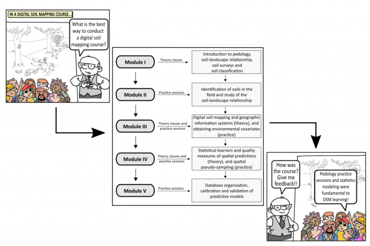
The use of new technologies, the development of new software, and the advances in the machines ability to process data have brought a new perspective to soil science and especially to pedology, with the advent of digital soil mapping (DSM). To meet the demand for soil surveys in Brazil, it will be necessary to popularize the techniques used in DSM. To identify and map the soil to generate maps of land use capability, we proposed a theoretical and practical course focused on the training in DSM for professionals involved in the management of land resources. The methodology was divided into five modules: I. Introduction to pedology, soil-landscape relationship, soil survey and soil classification (theory); II. Identification of soils in the field and study of the soil-landscape relationship (practice); III. Digital soil mapping and geographic information system (theory) and obtaining environmental covariates (practice); IV. Statistical learners and quality measures of spatial predictions (theory) and spatial pseudo-sampling (practice); V. Database organization, calibration, and validation of predictive models (practice). Results such as the average level of confidence of the participants in the soil classification, as well as the number of pseudo-sampling classified by the participants, chosen statistical apprentice, environmental covariates used, and overall accuracy, were influenced by the participants level of knowledge regarding DSM soils and techniques. The structure, focus, and time of each module should be based on the participants needs. It is suggested that a survey should be carried out to consider the level of knowledge in relation to the topics addressed in DSM before the preparation and execution of the course. The contribution of individual experiences showed the importance of multidisciplinarity in the teaching-learning process because it is a technique that involves soil knowledge, statistics, and mathematics applied to geoinformation science to understand soil variability in the landscape. The practical classes were fundamental, enabling an approximation of the content studied with the participants’ reality and consolidation of the acquired knowledge. In general, the course was well evaluated by the participants regarding the contents covered and practical field training and laboratory geoprocessing, who reported that the practical classes were fundamental for the appropriation of knowledge in DSM. This course could be a model for the PronaSolos, which tend to have heterogeneous groups of participants, being necessary to plan specific protocols to tend the particularity.
Agradecimentos
Agradecemos ao Dr. Antonio Carlos de Azevedo pelos comentários que melhoraram bastante o manuscrito.