Resumo
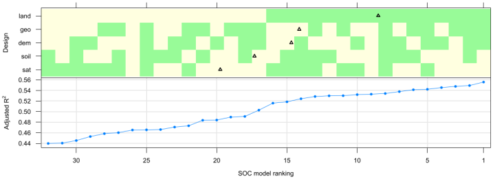
In this study we evaluated whether investing in more spatially detailed environmental covariates improves the accuracy of digital soil maps. We used a case study from Southern Brazil to map clay content (CLAY), organic carbon content (SOC), and effective cation exchange capacity (ECEC) of the topsoil for a ~ 2000 ha area located on the edge of the plateau of the Paraná Sedimentary Basin. Five covariates, each with two levels of spatial detail were used: area-class soil maps, digital elevation models (DEM), geologic maps, land use maps, and satellite images. Thirty-two multiple linear regression models were calibrated for each soil property using all spatial detail combinations of the covariates. For each combination, stepwise regression was used to select predictor variables incorporated in the model. Model evaluation was done using the adjusted R-square of the regression. The baseline model, calibrated with the less detailed version of each covariate, and the best performing model were used to calibrate two linear mixed models for each soil property. Model parameters were estimated using restricted maximum likelihood. Spatial prediction was performed using the empirical best linear unbiased predictor. Validation of baseline and best performing linear multiple regression and linear mixed models was done using cross-validation. Results show that for CLAY the prediction accuracy did not considerably improve by using more detailed covariates. The amount of variance explained increased only ~2 percentage points (pp), less than that obtained by including the kriging step, which explained 4 pp. On the other hand, prediction of SOC and ECEC improved by ~13 pp when the baseline model was replaced by the best performing model. Overall, the increase in prediction performance was modest and may not outweigh the extra costs of using more detailed covariates. It may be more efficient to spend extra resources on collecting more soil observations, or increasing the detail of only those covariates that have the strongest improvement effect. In our case study, the latter would only work for SOC and ECEC, by investing in a more detailed land use map and possibly also a more detailed geologic map and DEM.